
Wildlife map via satellite
 Scientists have drawn a conservation map for the world's richest biodiversity in Madagascar, which could fundamentally change the way conservation priorities are mapped across the world.
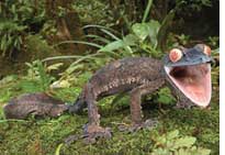
Unlike most conservation projects that focus on particular species, the study used satellite technology to identify areas most important for saving the highest percentage of fauna and flora. It highlights habitats that need urgent protection. The scientists took high resolution images of the 58-million hectare island of Madagascar and analyzed more than 2,300 species from six major groups: lemurs, butterflies, frogs, geckos, ants and plants over a wide area. Madagascar is renowned for its variety of wildlife with 80 per cent of its 30,000 known species found nowhere else on the planet.
Related Content
- Assessment report by the Space Applications Centre regarding encroachment inside wild ass sanctuary, Little Rann of Kutch, Gujarat, 31/03/2023
- Order of the National Green Tribunal regarding forest fire control, 28/05/2019
- Benin park plans to become elephant sanctuary
- Panda's habitat 'shrinking and becoming more fragmented'
- State of Antarctic Penguins 2017
- Coastal leatherback turtles reveal conservation hotspot