
Waters of woe
 WHEN the Himalaya mountains rose to replace the Sea of Tethys it seems they made a pact with nature. The Himalaya, the world's youngest fold-mountain range made up of friable rock, due to the very nature of their being contribute to the flooding of the Indo-gangetic plain. This year the Himalaya kept its pact with nature with a vengeance. First came the landslides, some which made news like the one at Malpa in India. Now have come the floods.
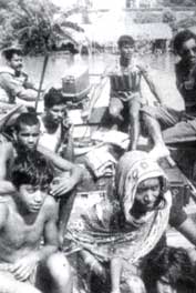
The northeast states have virtually been cut off from the rest of the country as the Ganga and the Brahmaputra rivers have broken banks in unprecedented ways. Roads and railway tracks have been submerged along with millions of homes in these region.
Incessant rains and landslides have paralysed life in several districts in the north and eastern parts of the country as well. By September 7, the floods had claimed 1,218 human lives in Uttar Pradesh, 299 in Bihar and 130 in West Bengal.
In Assam, road traffic has been paralysed and so far 300,000 people have been affected. The 430 square kilometre Kaziranga National Park in Assam is under six metres of water, displacing the world famous one-horned rhinoceros and 14 other threatened animal species. For the first time in the century, the Diphaloo river, which runs through the park, has merged with the mighty Brahmaputra.
About 70 per cent of the park area is inundated regularly during floods. The partially submerged artificial highlands around the park are now crowded with animals from the park. "There is nothing to protect inside the park," says a park official. A group of forest guards has started patrolling the National Highway 37 that cuts through the park to avoid speeding vehicles from killing animals seeking shelter. In Arunachal Pradesh too, eight districts have been hit badly so far.
In the lower reaches in Uttar Pradesh, over 2.5 million hectares (ha) of fields and grasslands has been inundated. The Ganga, Rapti and Ghagra rivers have destroyed the districts of Barabanki, Faizabad, Azamgarh and Gorakhpur. In the absence of fodder, hundreds of cattlehead have also perished.
During floods, rivers overflow into adjoining lands, often breaking embankments. The natural drainage of the land is blocked by man-made structures, such as roads. The spread of irrigation canals has also led to water-logging and consequent salinisation of the land.
The government and relief agencies have pumped in millions of rupees into flood prevention and relief operations. These have usually been in the form of embankments, drains, dams and related infrastructure built to control floods. But embankments have often worsened the flood impact.
In 1957, a high-level government committee noted that embankments can actually cause floods by leading to silt deposition within the embanked area. Himalayan rivers carry an extraordinary high amount of silt. Between themselves, the Ganga and the Brahmaputra account for an eighth of the entire silt load of all the rivers in the world. This results in the raising of the river bed level above that of the adjoining land, leading to breaching of embankments. Embankments also prolong the problem of water-logging in adjoining areas by hindering the retreat of floodwaters, thus making the floods last longer.
Reports based on satellite imagery from Malda, one of the worst-hit districts in West Bengal, suggest that the Ganga has often naturally changed its course in its flood plain. Images also show that the areas near embankments are wet and unstable due to water-logging. Experts have warned that people living near these embankments are open to the risk of being overwhelmed by a deluge.
The major flood years in India were 1955, 1971, 1978, 1988 and 1996. In 1996, 7.420 million ha land was submerged, 39,4 million people were affected and over 2,000 people died in the floods. In 1988, the figures were far greater, when 16 million ha was submerged, and floods killed over 4,500 people. The estimated economic loss was Rs 1.8 million in 1996 and Rs 4.6 million in 1988. The damage has been calculated in terms of the area under crops, loss of property, both public and private, and number of livestock killed.
Related Content
- Response by National Mission for Clean Ganga (NMCG) on STPs in Uttarakhand, 18/04/2024
- Exploring ways to fill Delhi’s unmet water needs
- Report filed by the Delhi Pollution Control Committee (DPCC) regarding violation of Noise Pollution Rules, 2000 by some of the restaurants, bars in Hauz Khas village, Delhi, 16/04/2024
- Order of the National Green Tribunal regarding removal of debris dumped at Mithi river, Mumbai, Maharashtra, 15/04/2024
- Order of the National Green Tribunal regarding non-compliance of environmental norms by Ashapur Meinchem, village Rowale, district Ratnagiri, Maharashtra, 15/04/2024
- Status report on behalf of Government of NCT of Delhi regarding regulation of borewells in Delhi, 15/04/2024