
The awakening of an ill tempered giant
 IN MARCH 1991, Aeta tribals living in Pinatubo region felt a rumbling in the long-dormant volcano. Birds and animals also exhibited showed signs of agitation. Here is an account of what followed:
April 2: A hydrothermal explosion shakes the area, forcing columns of steam upto 800 m high from vents on Pinatubo's slopes. The Philippines Institute of Volcanology and Seismology (Phivolcs), based in Quezon City, sounds an Alert Level 1 warning, which means an eruption is not imminent, but there is reason for caution.
April 4: Phivolcs gets a report from Sister Emma, an activist working in the Pinatubo area, that an explosion rocked Pinatubo's crater on April 2. A Phivolcs quick-response team locates five steaming vents on the volcano's northwest summit. A temporary seismic station is set up at Sitio Yamut, about 12 km to the northwest, and it records 223 high-frequency volcanic earthquakes. Four of the quakes are accompanied by rumbling, indicating rocks are breaking up under pressure exerted by the escaping steam.
April 9: Phivolcs declares a 10-km area around Pinatubo to be a danger zone and advises people to stay away. More seismic stations are set up and Phivolcs scientists work with US Geologic Survey personnel to install a seismic telemetry network to relay data to the Pinatubo volcano observatory set up at Clark air force base. The observatory is responsible for conducting topographic mapping, photo analyses and field identifications of hazards in the event of an eruption.
May 11: The periodicity of volcanic quakes moves up from between 50 and 90 a day to 167. Strangely, the frequency then drops drastically.
May 17: Phivolcs sounds Alert Level 2 after measuring the sulphur dioxide content of the volcanic steam discover that magma -- molten material at high temperature -- is rising and is less than five km below the summit.
Phivolcs has prepared a hazard zonation map and plotted the scope and nature of the impending Pinatubo eruption. Several worst-case scenarios are discussed with government authorities.
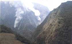
June 3: Around 7:30 am, Pinatubo spews ash for about 30 minutes and then in shorter outbursts.
June 6: Alert Level 3 is raised following tremors of longer duration and frequent underground water explosions. The sulphur dioxide content of ash-laden steam decreases suddenly, indicating magma has risen close to the surface and plugged the passage of volcanic gases.
June 7: More ash is ejected and the tremors become longer. Alert Level 4 is raised, indicating a major eruption is possible within 24 hours. An area within 20 km of Pinatubo is declared a danger zone and evacuation of the region is ordered.
June 8: At 3:25 pm, a sudden surge in seismicity is recorded as an explosion-type earthquake. The Pinatubo volcano observatory at Clark air force base detects a 30-m high formation of hardened lava at the summit of the central vent of the dome.
June 9: The volcano spews ash-laden steam clouds from 6 am to 2:40 pm. Pyroclast (rocks formed in an eruption) starts rolling down the northwest and western slopes of the mountain into the Maraunot and the Moraza rivers. Alert Level 5 is hoisted to indicate an eruption is in progress.
June 12: A second eruption occurs at 8:51 am. A huge, mushroom cloud rises 20 km over the region. Ash, pumice stones and large volcanic fragments are scattered thickly on the northwestern, western and southwestern sides of the volcano. Pyroclastic material flows into the rivers coming from the Pinatubo volcano, destroying everything in its path. In the night, a second series of explosions occurs, shooting ash-laden steam 25 km high and showering volcanic fragments more than 22 km away.
June 13: Another volcanic eruption takes place at 8:41 am, triggering heavy ashfalls on the Zambales, Tarlac and Pampanga provinces.
June 14: At noon, a series of earthquakes and explosions occurs, accompanied by ejection of ash to a height of 25 km. A bigger eruption at 3:20 pm propels a column 30 km above the vent. Pyroclastic flows cascade down the Maraunot river for 15 km. Phivolcs proclaims a 40-km radius danger zone and the towns of San Marcelino, San Antonia and San Narcisco -- all in Zambales -- become ghost towns.
June 15: The eruption continues and a tropical storm rages over the area. At 7 am, volcanic activity seems to subside, but what has actually happened is Pinatubo's mouth has become choked. Half an hour later, there is a succession of eruptions and ash emissions rise in 40-km columns. An estimated 7.5 million cubic metres of volcanic debris is thrown out and pyroclastic flows move southwest at great speed, reaching areas 15 km away.
Pinatubo's summit disappears and its elevation is reduced from 1,745 m to 1,400 m. Nineteen eruptions are recorded and eruption clouds disperse and drift in various directions, thanks to a typhoon that occurs at the same time. In Manila, more than 100 km away, afternoon turns into night as ash, sand and volcanic dust settle over many sections of the city.
After June 16: Volcanic activity declines both in frequency and magnitude. Minor eruptions occur on an average of three a day between the third week of June and the third week of July; twice daily till mid-August, and once a day till the end of August. Only three eruptions are recorded in September -- the last on September 4.
(Source: Philippine Institute of Volcanology and Seismology)