
The science of spatial information
 • global warming
Showing changes in sea temperatures and sea-level rise and their effect on fish movement
• philanthropy
Determining how much money is donated to the arts versus impoverished areas
• rural marketing
Keeping track of rural outlets and plotting the best supply routes to show increasing sales
• telecom
How does one make sure that phone lines are not clogged? How does one go about decongesting them?
• mining
Its effect on the quality of soil
• comuter patterns
Where are the heavily travelled traffic corridors? Where would light rail systems work?
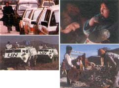
• war
Coordinating the movements of troops, among other things
• security systems
How to hold mega-events like the Olympics in a crime-free environment
• gentrification
Analysing property assessments on ageing areas to account for the real value of a property
• archaeology
Reconstructing an old castle, or a long-forgotten township, from its ruins
• relief
Rushing mobile kitchens, assessing damage due to natural disasters and coordinating flow of goods and services
Related Content
- Benthic communities of mesophotic coral ecosystem off Puducherry, east coast of India
- South African risk and vulnerability atlas
- Satellite observed water quality changes in the Laurentian Great Lakes due to invasive species, anthropogenic forcing, and climate change
- Mapping biodiversity priorities: a practical, science-based approach to national biodiversity assessment and prioritisation to inform strategy and action planning
- Economic and Social Survey of Asia and the Pacific 2016: Nurturing productivity for inclusive growth and sustainable development
- Tsunami hazard warning and risk prediction based on inaccurate earthquake