
Simply unpredictable
 IT BEGINS in the spring, when the sun"s rays start to warm the Indian subcontinent. And by June 23, the summer solstice, as the longest day is known, earnest Doordarshan newsreaders recite the familiar litany: "Light or isolated heavy showers are likely in some places, in the next 24 hours. Heavy showers accompanied by thunder and lightning are also likely on the west coast. A monsoon depression moving over the Bay of Bengal may bring heavy rain to parts of north eastern India."
The monsoon, which brings to India the rain that is the lifeblood of Indian farming, first came to the subcontinent between 60 million and 80 million years ago. Since then, the only predictability about the monsoon is the unpredictability of its exact arrival date. In the 17th century, British astronomer Edmund Halley, who discovered the comet that swings past the earth every 76 years, postulated that the monsoons are sea and land breezes on a planetary scale. Indian researchers from a variety of disciplines and using models of extreme complexity, have been the studying the phenomenon to obtain answers to such crucial questions as when it will actually hit Indian shores and with how much rain it will bless the farmer.
Says P R Pisharoty, the grand old man of the Indian monsoon who was formerly with the Physical Research Laboratory in Ahmedabad, "Willy-nilly, the monsoon will come each year, but what confounds and occupies scientists is: once the monsoon comes, how variable and unreliable the rainfall will be and, more importantly, what makes it so."
What researchers have been able to determine is that the monsoon is an extremely complex occurrence that is fully integrated with the global circulation system. Interactions between the winds and the ocean may bring either torrential rain or severe drought to the subcontinent. The researchers" problem is that complex details as fast-moving jet streams at various heights in the atmosphere, low-pressure systems, high temperatures, the Asian snow cover and the towering Himalaya determine what the monsoon will bring in its wake. No wonder meteorologist J Joseph shrugs helplessly and says, "The monsoon is like the human brain. We know of it, but we don"t know it."
Elusive definition Even defining the monsoon beyond stating that it blows from the southwest from roughly June to September and then shifts to come in from the northeast from October to December seems to elude consensus. Says P K Das, a former director general of the Indian meteorological department (IMD), "Though there is lack of agreement (among scientists) on a precise definition of the term monsoon, it is used to connote a seasonal wind that blows with consistency and regularity from one direction for part of year and which blows from another direction for the rest of the year."
Nevertheless, meteorologists and scientists have gained considerable understanding of the mechanics of the monsoon. But they are aware that much more needs to be learned from their observational and theoretical research. R N Keshavamurthy, director of the Indian Institute of Meteorology in Pune, notes, "Efforts to understand the monsoon are essential if one is to be able to predict it with any certainty." How important it is to predict accurately can be gauged by the fact that the summer monsoon from the southwest gives India about 70 per cent of its annual rain.
How does the monsoon occur? As the sun is observed to move northward from over the Tropic of Capricorn towards the Tropic of Cancer, the large Asian land mass and especially the elevated Tibetan plateau is heated by the sun"s increasingly direct rays. On the summer solstice, they fall directly on the Tropic of Cancer, which traverses Kuchch and Central India. Because water conducts heat more efficiently, the Asian land mass heats up much more than the surrounding sea, resulting in the creation of a giant surface low-pressure area or heat low, extending from the Sahara to Central Asia through Arabia and the arid zones of Pakistan, Rajasthan and Central India.
This trough alters the general air circulation in the region. Trade winds usually blow from subtropical high-pressure regions that extend across the globe in the mid-latitudes to low-pressure regions at the equator. They are then deflected by what scientists call the Coriolis force, generated by the earth"s rotation, so they flow southeastward in the southern hemisphere and northeastward in the northern hemisphere, towards the equator. The trade winds converge at the inter tropical convergence zone (ITCZ), a low-pressure region at the equator with ascending air and maximum cloudiness. In the east-west orientation, the cloud band may extend upto 3,000 km and 300-500 km in the north-south orientation. Air rising from the ITCZ finally subsides over the 30o North latitude, thereby completing the circulation called the Hadley cell.
Explains monsoon researcher Sulochana Gadgil of the Centre for Atmospheric Sciences at the Indian Institute of Science in Bangalore, "Unravelling the factors that determine the location, extent and intensity of the ITCZ in a specific season is perhaps the most challenging problem in the understanding of monsoon meteorology on a planetary scale."
When low pressures build up over the Indian subcontinent, the ITCZ shifts to the north of the equator, merges with the heat low and develops into the monsoon trough -- a low-pressure belt that extends across the country. However, Gadgil notes, "The surface trough is associated with a tropical convergence zone only over some regions."
Nonetheless, the heated Indian subcontinental land mass, acting somewhat like a large heat engine, draws cool sea winds and changes the prevailing wind pattern into a sort of reverse Hadley cell. The result is that the southeast trade winds from the southern hemisphere, drawn by this low pressure belt over India, cross the equator, get deflected to the right and blow over India as the southwest monsoon.
As might be expected, not all scientists agree with this explanation of how the monsoon occurs. Some of them insist that the monsoon trough and the ITCZ are separate.
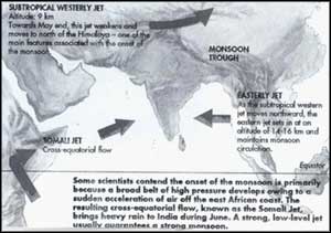
Just about the time the monsoon is about to lash the Kerala coast with a sudden burst of torrential rain, changes become apparent in the different layers of the atmosphere. This has led some scientists to suggest that the monsoon"s onset is related to a sudden acceleration of air from the southern hemisphere toward India. They say a broad belt of high pressure develops around the Mascarene Islands near Mauritius in the Indian Ocean and this generates the cross-equatorial flow known as the Somali jet, which brings heavy rain to India"s west coast. Says G S Mandal, a scientist with IMD, "A strong, low-level jet usually means a strong monsoon over peninsular India."
But before the first monsoon showers arrive, other atmospheric actors get into position to play their roles. Scientists now know that towards the end of May, on the eve of the onset of the monsoon, a narrow stream of air in the upper atmosphere, which normally moves from the west to the east at a height of about 9 km over northern India, suddenly weakens and moves to the north of the Himalaya. As this stream -- called the subtropical westerly jet -- moves north, an easterly flow of air -- the easterly jet -- concentrates at a height of 14-16 km, producing a divergence of air in the upper-levels of the atmosphere that is necessary to maintain monsoon circulation. However, if this easterly jet"s high speed is maintained for two or three days, scientists now know that a so-called break-monsoon -- a condition during the monsoon season when a dry spell develops in northern India -- is likely to develop.
When all these processes combine, the hot, dry air above the sun-heated Indian subcontinent is replaced entirely with cool, moist, ocean air upto an altitude of 3-5 km. It is in this air-replaced zone that the spectacular display of lightning that is a characteristic of tropical storms takes place.
Whimsical variations
The monsoon trough that develops almost parallel to the Himalaya is a capricious low-pressure region whose continued existence requires a number of processes. Scientists say that when the monsoon clouds release their moisture, a great deal of latent heat is released as vapour turns to water and this heats up the air, which maintains high temperatures and low pressures in the monsoon region. The continual migration of low-pressure depressions from above the Bay of Bengal also feeds the monsoon trough, bringing rain to northwestern and central India.
Scientists are well-aware of the whimsical behaviour of the monsoon and especially that its variability occurs on several time-scales. Variations on a five- to seven-day scale, they say, are due to disturbances such as lows, depressions, storms and cyclones. Mandal, for example, notes that the amount of rainfall depends on the frequency, intensity, life-cycle and propagation characteristics of these disturbances. Scientists now know that monsoon vagaries on a 10- to 15-day time-scale are related to the behaviour of the monsoon trough. When positioned normally over the Gangetic plains, it controls moisture convergence and rainfall and areas within upto 500 km on either side of the trough get moderate, but well-distributed, rain. However, the trough is not stationary and scientists explain that it sometimes moves northward and closer to the Himalayan foothills and this can interrupt rainfall in the northern plains.
Despite all the uncertainty from confusing signals that leaves one guessing about when it will rain, scientists are gradually seeing the emergence of patterns in the monsoon"s seemingly erratic behaviour. For instance, they have discovered that 30-50 day oscillations occur not only in the amount of rain that falls but also in the associated pressure and temperature conditions. Keshavamurty says the monsoon takes about 30 to 50 days to journey across the ocean and country. As a result, a band of maximum cloudiness that develops over the equator and then moves northward bringing rain to India, is replaced by another that also develops over the equator. This initiates a 30-50 day cycle of active monsoon phases, though some scientists say that latest research shows that the length of the cycle can vary from one year to the next.
Complicated process
Meanwhile, meteorological phenomena occurring on the other side of the globe also influence the monsoon. Explains Pisharoty, "The monsoon is a truly global phenomenon as it is part of the earth"s general circulation. As apparently unrelated phenomena on the other side of the globe can have an impact on our monsoon, understanding the processes that drive the monsoon is all the more complicated."
Ever since former science and technology secretary Vasant Gowariker made his 16-parameter, long-range, monsoon-forecasting model public in 1988, the mere mention of El Nino is enough to start headaches in planning bodies. El Nino is the name given to an inexplicable warming of the waters of the equatorial Pacific, off the coasts of Peru and Ecuador, every 2-7 years.
Scientists rate El Nino as the leading factor in disturbing climate patterns and say it is closely linked to the performance of the Indian monsoon. The atmospheric pressure caused by El Nino causes changes in patterns, including an alteration in the direction of the prevailing trade winds, and this affects the monsoon. U C Mohanty, joint director of the Centre for Medium Range Weather Forecasting (CMRWF) in New Delhi, notes deficient monsoons are common during the El Nino phenomenon. "Recent research shows," he says, "no flood monsoon year has been observed during an EL Nino episode."
The link between the Indian monsoon and atmospheric changes in the southern Pacific has been known since it was postulated by IMD"s first director-general, Gilbert Walker. Since then, scientists have been searching for teleconnections between the Indian monsoon and other global physical phenomena. And some of their recent findings are that the Eurasian snow cover, how hot the Tibetan plateau is and the speed of various jet streams at different atmospheric heights may seem unconnected, but they all appear to affect the monsoon.
Predicting weather
Because of the complex and global factors involved, predicting the weather accurately necessitates providing meteorologists with a complete breakdown of atmospheric factors practically around the globe. Even then, this immensely complicated task can be made more difficult because the factors involved are highly dynamic and they can and do change rapidly.
This explains why in early July, a Delhi newspaper front-paged a weather bureau assurance that there was no possibility whatsoever for the next two or three days, only to have the skies open wide that afternoon and leave some low-lying areas in the Capital under three metres of water.
Meteorologists even now base their weather forecasts on recognising weather patterns and identifying what such patterns produced in the past. Intricate, three-dimensional charts are plotted of atmospheric conditions over the area concerned, low- and high-pressure areas and their movement are identified and all these factors become the basis for forecasting the weather in that area over the next 24-48 hours.
But these methods, called synoptic because they summarise and analyse such data as winds, eddies, temperature and moisture, can provide predictions that are valid for only a few hours or at the most, a day or two. In fact, all too often, by the time a reasonable pattern is deciphered, the conditions would have changed.
However, scientists have achieved some success in using teleconnections between global phenomena to predict the monsoon season as a whole and they are now able to say with some accuracy whether the entire monsoon rainfall in India is likely to be normal, deficient or excessive. These predictions are based on relatively simple statistical models, such as the one evolved by Gowariker and his colleagues.
But some experts contend their success is based more on chance and not on a sound theoretical understanding of the correlations between monsoon rainfall and global monsoon indicators such as El Nino. They insist that the Gowariker model only provides an overall picture of the season"s total rainfall over the whole country, which, of course, is useful to policy-planners. However, for forecasting to be useful to ordinary farmers, who are among the most dependent on monsoon rain for their livelihood, most experts agree that the forecast must concern smaller, specific areas and be valid for three to 10 days. Only then will farmers be able to plan their agricultural activities with any certainty.
The government"s recognition of the crucial need to improve the capacity to predict weather correctly is expressed in the setting up of the CMRWF. It is this range of forecasting the represents the real challenge to Indian meteorologists, for it is a Herculean task that can involve working out billions of calculations for a valid prediction. Obviously, such complex computations require impressive computer facilities and these have been installed at the forecasting centre.
Despite all this, most scientists agree that much about monsoon is still shrouded in mystery. Says B N Goswami at the Indian Institute of Science, "It is a pity that Indian meteorology has not progressed the way it should have." Indian scientists, he elaborates, have been exceptionally inward-looking and obsessed with analysing regional data and only in the past two decades have they started looking at the monsoon"s global aspects.
However, their emphasis is slowly shifting and in the past 10 years, there has been considerable improvement in numerical weather prediction models. Taking their cue from the West, where the first mathematical models were developed, and using equations to represent atmospheric and oceanic circulations, Indian scientists have been working on monsoon models based on both regional and general circulation.
CMRWF scientists have been working since 1990 with general circulation models that are refined versions of a model obtained from the US national meteorological centre. Comments Keshavamurty, "There has been a virtual revolution in the science of meteorology, with vastly improved tools such as satellites and supercomputers."
But these modelers complain global circulation models fail to simulate monsoon conditions because the models appear to work for only parts of the tropics and the mid-latitudes. In the monsoon region, however, the models are unable to simulate the effect of local phenomena because these are highly variable and preclude averaging for a longer time frame, which is essential for long-range forecasting.
At present, says Goswami, the models adequately simulate rainfall over the northern Bay of Bengal and over the Western Ghats, but not for the whole of the Indian land mass. Another problem is that monsoon models are extremely sensitive to the initial inputs. Explains Keshavamurty, "Data received, especially from ships, often could be as much as 20-30 per cent off the mark. When fed into a model, this will create completely absurd simulations."
And, Goswami adds, "It was assumed that initial conditions should not make a great difference to the model"s behaviour. But we find that if February 1 conditions instead of February 2 conditions are used, they just don"t work in some models."
Data initialisation and parameterisation -- making data obtained at widely separated observation points or grid points relevant to the particular region at a particular time -- are two major thrust areas of research. Though the physics of the various processes on a small scale, such as cyclones, lows and clouds is known to some extent, scientists say it is difficult to parameterise these for areas within grid points. Hence, Indian scientists stress it is imperative to develop their own modelling methods.
It is to address these problems and others linked to monsoon modelling that the Monsoon Numerical Experiment Group was set up in 1989. The group consists of numerical modelers engaged in research in several parts of the world and they collaborate in seeking to fine-tune available models simulating the southwest monsoon in India.
But scientists stress that computers and mathematical models apart, valid forecasts require a thorough understanding of the physics of the monsoon. Says Mohanty, "Once the basic physics of the several mechanisms that govern the monsoon are worked out, we will be able to predict the weather on a three- to 10-day time-scale."
Monsoon physics
But the physics of the tropics, warns Pisharoty, poses special problems. Using a medical metaphor, he explains, "Our fever is different and we have to find our own medicine. We cannot borrow models developed in other parts of the world and use them to predict our monsoon." Giving an example, he pointed out the equations governing the transfer of water vapour to the atmosphere have to be developed through experimentation here, because temperatures in the tropics are higher and so evaporation equations for the Indian region are bound to be different.
And Mohanty adds, "In the mid-latitudes, the dynamics of the system drive the weather in the medium range. Forecasters can tell which way a front is likely to move. But in India, small-scale physical processes that are highly variable in time and space, drive the system and make conditions more complex."
Most scientists agree theory alone cannot lead to better models and what is essential are accurate data available on a smaller scale and experiments to test the models. Keshavamurty explains, "We can continue to sit in the lab and develop complicated mathematical models to represent the phenomena, as a number of atmospheric scientists are now wont to do, but these will have little meaning if the physics that govern monsoon phenomena is only partially understood."
Author C S Ramage echoes this opinion in his seminal book Monsoon Meteorology and makes this scathing comment: "Conceivably, Nairobi and Pune meteorologists exchanging visits make better sense than spending time at great computing centres where they may learn to perform minor cosmetic surgery on the latest nine-level primitive general circulation model."
Presently, weather-related data is collected at more than 12,000 stations across the globe, most of them on land. To predict Indian weather with reasonable accuracy, data has also to be collected specifically from and above the seas that surround the much of the country. Attempts to collect such data were first made in the late 1970s through MONEX, as the international summer monsoon experiment came to be called. A more recent attempt is an experiment to collect land data, launched in 1988 by the department of science and technology (DST) and called the Monsoon Trough Boundary Layer Experiment, or MONTBLEX.
The DST experiment sought to investigate the effects of the boundary layer -- the region of the atmosphere where the thermodynamic and dynamical effects of the earth are felt -- on the maintenance of the monsoon trough. Using sophisticated technology -- like meteorological balloons and sodars -- developed indigenously, field data was generated during the 1990 monsoon season. Observations of winds, temperature and humidity were made at various levels of the atmosphere, at Jodhpur, Delhi, Varanasi and Kharagpur. Soil temperatures also were measured. The data generated has not been fully analysed, but scientists are optimistic that it will lead to a clear understanding of the behaviour of the monsoon trough.
DST scientist Malathi Goel says the MONTBLEX data will enable scientists to set parameters for the processes of the boundary layer. And Keshavamurty notes that setting parameters, which involves making data collected at widely spaced grid points relevant to the micro-level physical processes within a grid square, is an extremely important area of research. Much of the effort in future will be made in this area to make monsoon models more relevant.
With such detailed and widespread attempts being made by experts in India to gain full understanding of the monsoon phenomenon, scientists confidently predict that before long they will be able to provide both farmer and policy-makers well in advance an accurate picture of the rain clouds in Indian skies.